Pennsylvania | Laurel Highlands
Youghiogheny River
Lower Yough: Ohiopyle to Bruner Run
Check current paddling conditions for this Youghiogheny River route, including water level, recent gauge trend, weather, and route details.
Route snapshot
Loading the route snapshot. This usually takes a few seconds.
Today
Get the answer fast, then scan the route.
Start with the verdict, current conditions, route plan, and quick facts before you commit to the drive.
Today's conditions
Gauge
Recent trend
Checking preferred range.
Checking trend.
Gauge source
-- Checking timestampMN DNR provides the current paddling level here, but not chart-ready recent samples.
Weather
Best window today
Checking weather.
Today by hour
Short-route forecast
Checking the next several hours.
Quick facts
Plan
Dial in the shuttle, distance, and access.
Use this section once the route looks viable and you need to turn it into an actual trip plan.
Access plan
Access, shuttle, and map
Launch below Ohiopyle Falls at the state-park Lower Yough launch and take out at Bruner Run for the classic Lower Yough whitewater run. Use the Ohiopyle USGS stage gauge and current park rules, and skip the route when the water, weather, access status, or group skill is not clearly right.
Put-in
Ohiopyle State Park Lower Yough launch Open mapThis route starts below Ohiopyle Falls; running the falls has separate DCNR access rules and is not part of the normal route recommendation.
Take-out
Bruner Run Take-out Open mapLaunch tickets are required during the DCNR managed season. Weekend and holiday launch tickets carry a fee, and current shuttle/gate operations can affect how you retrieve boats and vehicles.
Pulling access map tiles. Usually under 5 seconds.
Access caveats
- This route starts below Ohiopyle Falls; running the falls has separate DCNR access rules and is not part of the normal route recommendation.
- Launch tickets are required during the DCNR managed season. Weekend and holiday launch tickets carry a fee, and current shuttle/gate operations can affect how you retrieve boats and vehicles.
- The put-in and take-out coordinates are American Whitewater feature coordinates cross-checked against DCNR route names, not a DCNR coordinate table. Use current state-park signs and staff instructions on arrival.
- Bruner Run access has had construction and closure history. Check current Ohiopyle State Park notices before assuming the take-out road, shuttle, or lower loading area is open.
- Only whitewater-suitable craft belong on this route. DCNR says inexperienced whitewater boaters should use qualified guides, and all boaters must follow DCNR whitewater rules.
Watch for
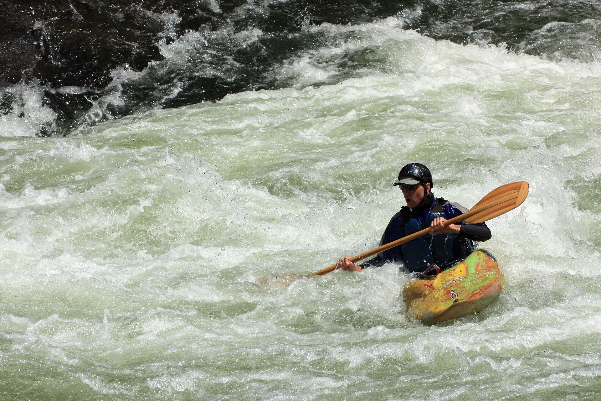
- Class III-IV rapids, including Entrance, Cucumber, Railroad, Dimple, Swimmers, Schoolhouse, River End, and Bruner Run.
- Dimple Rock and other undercut or entrapment hazards, ledges, hydraulics, pin rocks, swift current, and cold swims.
- Low water near the bottom of the AW range, where rocks and pins become more exposed, and high water above about 4 ft where hydraulics and pushier current increase.
- Water at or above about 7 ft on the Ohiopyle gauge, which AW classifies as high to extremely high Class IV-V and outside this general recommendation.
- Crowded commercial/private traffic, limited eddies, group separation, bridge and trail spectators near Ohiopyle, storms, release changes, and missing the Bruner Run take-out.
Route gallery
See this route on the water
Photos help show what the access looks like and what the route actually feels like on the water.
Sources
Check the data behind today's call.
Use this section when the page shows stale data, limited confidence, or a call you want to verify before driving.
Why this score Today's data confidence is checking
Data confidence mostly comes down to three things: how direct the gauge is, how clear the range is, and how fresh the data is.
- Checking data confidence notes.
- Checking data confidence cautions.
Outlook Tomorrow and weekend
This is a cautious early look. If the data is too thin, we leave it out.
Waiting on forecast.
Waiting on forecast.
Data behind the score Gauge, thresholds, and timing
These are the live readings and threshold notes behind today's score.
| Gauge site | Youghiogheny River at Ohiopyle, PA |
| Gauge height | Checking |
| Discharge | Checking |
| 24h trend | Checking |
| 24h change | Checking |
| Current band | Checking |
| Rain last 24h | Checking |
| Rain last 72h | Checking |
| Air temp | Checking |
| Water temp | Checking |
| Wind | Checking |
| Gusts | Checking |
| Rain timing | Checking |
| Target band | 1.70 ft to 4.00 ft |
| Low threshold | 1.10 ft |
| High threshold | 7.00 ft |
| Data confidence behind the range | Official and local sources |
| Gauge observed | Checking |
| Paddle Today updated | Checking |
| Main source behind this score | American Whitewater Lower Yough Ohiopyle gauge bands |
| Gauge source | Checking |
| Weather source | Checking |
| Rainfall source | Checking |
Notes What to know before you go
These notes cover the access details, route quirks, and source caveats most likely to matter once you get there.
- Official route Seven miles to Bruner Run
DCNR says the Lower Yough begins after Ohiopyle Falls and flows seven miles downstream to the Bruner Run Take-out, with numerous Class III-IV rapids.
- Direct gauge USGS 03081500 at Ohiopyle
USGS operates Youghiogheny River at Ohiopyle, PA, 900 ft downstream from the Route 381 bridge and upstream from Meadow Run; Water Services returned same-day 2026-06-11 stage and discharge values during implementation.
- AW stage bands 1.1 / 1.7-4.0 / 7.0 ft
American Whitewater ties the Ohiopyle-to-Bruner-Run reach to USGS 03081500, lists 1.10-1.70 ft as barely to medium runnable, 1.70-4.00 ft as medium to a bit pushy runnable, 4.00-7.00 ft as pushy to high runnable, and 7.00 ft plus as high to extremely high Class IV-V.
- Access and permit context Launch ticket plus PA permit/registration context
DCNR says Lower Yough boaters must obtain a launch ticket during the managed season, and PFBC says unpowered boats need registration, a PFBC launch permit, or a DCNR State Parks launch permit to use PFBC or Pennsylvania State Parks and Forests access areas.
- Endpoint support AW feature coordinates
American Whitewater places the Ohiopyle State Park put-in below the falls at 39.866528, -79.493395 and the Bruner Run take-out at 39.926672, -79.487236; DCNR independently names the same route endpoints.
- Core hazards Class III-IV gorge whitewater
DCNR warns of undercut rocks, ledges, swift currents, injury and death potential, and required PFDs and helmets on the Lower Yough; AW highlights Dimple Rock entrapment risk and pushier hydraulics at higher stages.
Verify it yourself Check the source links
Use these links to double-check the gauge, route details, and access notes before you head out.
Paddler reports
Recent notes from paddlers
A few quick notes from people who were on this route recently.
Reports
Photos, paddler notes, and updates.
See what others have shared, then add a condition report, upload photos, or flag anything that needs fixing.
Share your trip
Keep exploring
More routes to check next
Compare another stretch on this river, or jump to nearby options before you pick a plan.
More in Pennsylvania
All 2 routesNearby routes by distance
Quick answers
Youghiogheny River paddling FAQ
What water level is good for paddling Youghiogheny River?
Paddle Today watches Youghiogheny River at Ohiopyle, PA and treats 1.70 ft to 4.00 ft as the target band for this route, with weather and recent trend included in the final score.
Where does this Youghiogheny River route start and end?
This route starts at Ohiopyle State Park Lower Yough launch and ends at Bruner Run Take-out, about About 7 to 7.2 mi on the water.
Is this Youghiogheny River route good for beginners?
This is listed as a hard route. Treat the live score as a planning aid, then confirm conditions, hazards, access, and group skill before launching.
Flag a change
See something outdated?
Access, hazards, wood, and shuttle details change. Send a quick correction if something looks off.