State routes

South Carolina Rivers

Compare 36 tracked South Carolina paddle routes with route links, water-level context, difficulty, and access planning details.

24 routes support live scores. 12 planning-only routes provide trip details and source links without a live route score.

36 routes8 rivers8 regions13 beginner routes
Skip map

Loading supported rivers and route reaches.

End of map

Explore supported South Carolina rivers

Scan the highlighted river network from above, then use the route guides and access markers to find a supported reach.

36 route markers4 multi-route rivers13 beginner routes
Supported riverSelected reachAccess-point connectionStrong conditionsGood conditionsWatch closelySkip

Best South Carolina routes today

Loading current scores, gauge reads, and weather signals.

--Live
Clarendon / Williamsburg / Georgetown Counties

Black River

Gilland Memorial Park to Mill Street Landing

Easy | About 1 river miles | Allow 1–3 hours with current, landing and shuttle checks | Live score supported
View trip details
--Live
Clarendon / Williamsburg / Georgetown Counties

Black River

Pine Tree Landing to Pea House Landing

Easy | About 5 river miles | Allow 3–5 hours with side-channel navigation and heat margin | Live score supported
View trip details
--Live
Clarendon / Williamsburg / Georgetown Counties

Black River

Pump House Landing to Pea House Landing

Easy | About 10.3 river miles | Allow 4–6 hours with tide, side-channel navigation and wildlife stops | Live score supported
View trip details
--Live
Clarendon / Williamsburg / Georgetown Counties

Black River

Pump House Landing to Pine Tree Landing

Easy | About 5 river miles | Allow 3–5 hours with tide, side-channel navigation and heat margin | Live score supported
View trip details

Current scores load here when available. You can still open the route links to check details and sources if this update fails.

Good starting points in South Carolina

Ranked from route metadata, source support, difficulty, and logistics.
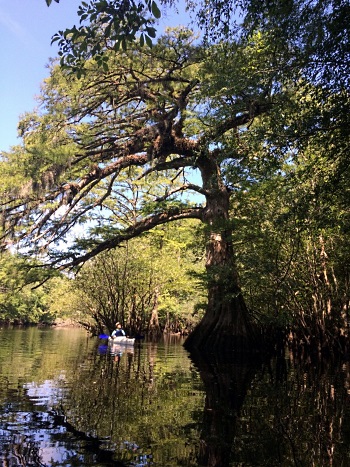
The Black Scenic River winds through cypress swamp in South Carolina.
South Carolina routeClarendon / Williamsburg / Georgetown CountiesBlack RiverGilland Memorial Park to Mill Street LandingA short Kingstree Black River connector between the Gilland Memorial Park ramp and the public Mill Street Landing.

Route facts

Easy | About 1 river miles | Allow 1–3 hours with current, landing and shuttle checks | Live score supportedofficial source support
The Black Scenic River winds through cypress swamp in South Carolina.
South Carolina routeClarendon / Williamsburg / Georgetown CountiesBlack RiverPine Tree Landing to Pea House LandingA lower Georgetown County Black River day reach between the side-channel Pine Tree dock and the Pea House public landing.

Route facts

Easy | About 5 river miles | Allow 3–5 hours with side-channel navigation and heat margin | Live score supportedofficial source support
The Black Scenic River winds through cypress swamp in South Carolina.
South Carolina routeClarendon / Williamsburg / Georgetown CountiesBlack RiverPump House Landing to Pea House LandingA documented Black River East day trip through the cypress narrows from Pump House Landing to Pea House Landing.

Route facts

Easy | About 10.3 river miles | Allow 4–6 hours with tide, side-channel navigation and wildlife stops | Live score supportedofficial source support
The Black Scenic River winds through cypress swamp in South Carolina.
South Carolina routeClarendon / Williamsburg / Georgetown CountiesBlack RiverPump House Landing to Pine Tree LandingA popular Black River Swamp introduction from Pump House Landing near Andrews to the Pine Tree side-channel landing.

Route facts

Easy | About 5 river miles | Allow 3–5 hours with tide, side-channel navigation and heat margin | Live score supportedofficial source support
Catawba River at Landsford Canal State Park in South Carolina, with shallow rocky shoals and wooded banks.
South Carolina routeYork / Chester / Lancaster CountiesCatawba RiverFort Mill River Access to Rock Hill River ParkA popular Charlotte-area Catawba reach from the Fort Mill public ramp below Lake Wylie Dam to Rock Hill River Park.

Route facts

Easy | About 7 river miles | Allow 3–5 hours with release and shuttle checks | Live score supportedofficial source support
Catawba River at Landsford Canal State Park in South Carolina, with shallow rocky shoals and wooded banks.
South Carolina routeYork / Chester / Lancaster CountiesCatawba RiverFort Mill River Access to Landsford Canal State ParkA staged Catawba itinerary linking the Fort Mill, Rock Hill and Landsford public access sequence below Lake Wylie Dam.

Route facts

Moderate | About 24 river miles | Plan a full daylight day with release, wind and shuttle margin | Live score supportedofficial source support

South Carolina beginner routes

These routes are tagged easy in the route data. Today's water can still change the call.

Showing 8 of 13 beginner routes. Use the Easy difficulty filter below to see the full set.

Routes with practical logistics

Use the live weekend board for score-based recommendations.

Rivers and regions

Expand a river or region to browse its routes.

By river

Broad River19
Catawba River6
Black River4
Edisto River3
Little Pee Dee River1
Lower Saluda River1
Lynches River1
North Fork Edisto River1

By region

Clarendon / Williamsburg / Georgetown Counties4
Colleton County3
Dillon County1
Lexington and Richland counties1
Orangeburg County1
Pee Dee / Florence County1
Upstate to Columbia / Broad River19
York / Chester / Lancaster Counties6

Every South Carolina route on Paddle Today

36 routes with condition and access details.

Showing all 36 routes.

Black RiverGilland Memorial Park to Mill Street LandingClarendon / Williamsburg / Georgetown Counties | Easy | Live score supportedBlack RiverPine Tree Landing to Pea House LandingClarendon / Williamsburg / Georgetown Counties | Easy | Live score supportedBlack RiverPump House Landing to Pea House LandingClarendon / Williamsburg / Georgetown Counties | Easy | Live score supportedBlack RiverPump House Landing to Pine Tree LandingClarendon / Williamsburg / Georgetown Counties | Easy | Live score supportedBroad RiverBroad River Landing to Neal Shoals Dam accessUpstate to Columbia / Broad River | Easy | Live score supportedBroad RiverBroad River Landing to Sandy River LandingUpstate to Columbia / Broad River | Easy | Planning only · no live scoreBroad RiverBroad River Landing to Shelton Ferry LandingUpstate to Columbia / Broad River | Moderate | Planning only · no live scoreBroad RiverBroad River Landing to Strother LandingUpstate to Columbia / Broad River | Moderate | Planning only · no live scoreBroad RiverLockhart below Dam #2 to Broad River LandingUpstate to Columbia / Broad River | Easy | Live score supportedBroad RiverLockhart below Dam #2 to Neal Shoals Dam accessUpstate to Columbia / Broad River | Easy | Planning only · no live scoreBroad RiverLockhart below Dam #2 to Sandy River LandingUpstate to Columbia / Broad River | Moderate | Planning only · no live scoreBroad RiverLockhart below Dam #2 to Shelton Ferry LandingUpstate to Columbia / Broad River | Moderate | Planning only · no live scoreBroad RiverLockhart below Dam #2 to Strother LandingUpstate to Columbia / Broad River | Moderate | Planning only · no live scoreBroad RiverNeal Shoals Dam access to Sandy River LandingUpstate to Columbia / Broad River | Easy | Live score supportedBroad RiverNeal Shoals Dam access to Shelton Ferry LandingUpstate to Columbia / Broad River | Moderate | Planning only · no live scoreBroad RiverNeal Shoals Dam access to Strother LandingUpstate to Columbia / Broad River | Moderate | Planning only · no live scoreBroad RiverNinety-Nine Islands River Access to Lockhart above Dam #1Upstate to Columbia / Broad River | Moderate | Planning only · no live scoreBroad RiverNinety-Nine Islands River Access to Worth Mountain WMA, Daltons LandingUpstate to Columbia / Broad River | Easy | Live score supportedBroad RiverPeak-Alston Canoe Access to Harbison State ForestUpstate to Columbia / Broad River | Moderate | Live score supportedBroad RiverSandy River Landing to Shelton Ferry LandingUpstate to Columbia / Broad River | Moderate | Live score supportedBroad RiverSandy River Landing to Strother LandingUpstate to Columbia / Broad River | Moderate | Planning only · no live scoreBroad RiverShelton Ferry Landing to Strother LandingUpstate to Columbia / Broad River | Easy | Live score supportedBroad RiverWorth Mountain WMA, Daltons Landing to Lockhart above Dam #1Upstate to Columbia / Broad River | Easy | Live score supportedCatawba RiverFort Mill River Access to Landsford Canal State ParkYork / Chester / Lancaster Counties | Moderate | Live score supportedCatawba RiverFort Mill River Access to Rock Hill River ParkYork / Chester / Lancaster Counties | Easy | Live score supportedCatawba RiverFort Mill River Access to SC 9 LandingYork / Chester / Lancaster Counties | Moderate | Live score supportedCatawba RiverLandsford Canal State Park to SC 9 LandingYork / Chester / Lancaster Counties | Moderate | Live score supportedCatawba RiverRock Hill River Park to Landsford Canal State ParkYork / Chester / Lancaster Counties | Moderate | Live score supportedCatawba RiverRock Hill River Park to SC 9 LandingYork / Chester / Lancaster Counties | Moderate | Live score supportedEdisto RiverMars Oldfield Landing to Good Hope LandingColleton County | Moderate | Live score supportedEdisto RiverMars Oldfield Landing to T.W. Messervy LandingColleton County | Moderate | Live score supportedEdisto RiverT.W. Messervy Landing to Good Hope LandingColleton County | Moderate | Live score supportedLittle Pee Dee RiverCarmichael's Bridge to Huggins BridgeDillon County | Moderate | Live score supportedLower Saluda RiverSaluda Shoals Park or Hope Ferry Landing to GardendaleLexington and Richland counties | Moderate | Planning only · no live scoreLynches RiverIndigo Landing to Wicklow LandingPee Dee / Florence County | Hard | Live score supportedNorth Fork Edisto RiverBaughman's Landing to Orangeburg City LandingOrangeburg County | Moderate | Live score supported

South Carolina paddling FAQ

How does Paddle Today choose South Carolina paddle routes?

Paddle Today lists source-backed routes with reviewed access and trip information. This page includes 24 routes with live-score support and 12 planning-only routes across 8 rivers. Planning-only routes do not have a live route score.

Are these South Carolina river conditions live?

Scored routes show the latest available conditions, subject to data availability. Planning-only routes provide trip information and source links without a live route score. Check update times and missing-data notices, and verify conditions with the linked managers before leaving.

Can I request another South Carolina route?

Yes. Use the request form to send the river, reach, access points, and any source links. Requests help prioritize useful additions with verified public access and route evidence.